
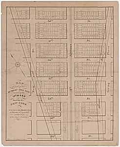
Map of part of the Murray-Hill Estate, Situated in the 12th Ward of the City of New York, to be sold by James Bleecker & Sons on Thursday 11th June 1835, at 12 o'clock, at the Merchant's Exchange
1835
Medium
Lithograph
Dimensions
Sheet: 23 1/16 × 18 11/16 in. (58.5 × 47.5 cm)
Classification
Prints
Department
Drawings and Prints
Museum
Metropolitan Museum of Art, New York, NY
Credit
The Edward W. C. Arnold Collection of New York Prints, Maps and Pictures, Bequest of Edward W. C. Arnold, 1954
Accession Number
54.90.1471
Rights
Public Domain
Tags
Art Historical Context
This 1835 lithograph captures a pivotal moment in New York City’s rapid expansion. Created by Prosper Desobry an auction notice for the-Hill Estate in the city’s 12th Ward, the was designed to promote the sale of land parcels on June 11 at the Merchant’s Exchange. At the time, Manhattan’s northern reaches were transitioning from rural estates to planned urban neighborhoods, and such printed maps served both practical and promotional purposes for developers and buyers alike. Desobry’s use of lithography—a relatively new printmaking technique—allowed for precise, reproducible detail that made complex property boundaries and street grids easy to read. The sheet’s generous size further emphasizes its role as a working document, likely posted or distributed to attract investors during a period of intense real-estate speculation. Today, the print offers modern viewers a vivid snapshot of early nineteenth-century urban planning. Part of the Metropolitan Museum’s Edward W. C. Arnold Collection, it illustrates how maps functioned as both informational tools and cultural artifacts that shaped the city’s growth.