
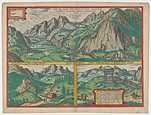
The Inn Valley from the series Civitates Orbis Terrarum, vol. V, plate 59
Medium
Etching with hand coloring
Dimensions
Sheet: 16 in. × 21 1/8 in. (40.7 × 53.7 cm) Plate: 14 9/16 × 19 7/8 in. (37 × 50.5 cm)
Classification
Prints
Department
Drawings and Prints
Museum
Metropolitan Museum of Art, New York, NY
Credit
Gift of Mrs. Giles Whiting, 1961
Accession Number
61.650.36
Rights
Public Domain
Art Historical Context
Welcome to the Metropolitan Museum of Art's Drawings and Prints department, where *The Inn Valley* from *Civitates Orbis Terrarum*, volume V, plate 59 (1590), offers a captivating bird's-eye vista of the scenic Inn Valley in the Tyrol region of present-day Austria. This etching with hand coloring, measuring about 16 by 21 inches on its sheet, is part of the most ambitious urban atlas of the Renaissance era—a six-volume masterpiece published between 1572 and 1617, documenting over 500 towns and landscapes across Europe, Asia, and the Americas. Compiled by canon Georg Braun, with engravings by Frans Hogenberg, Simon Novellanus, and intricate details by Joris Hoefnagel, the series blended cartography, topography, and artistry to capture the world's cities during an age of exploration and printing innovation. Etching allowed for precise lines depicting winding rivers, alpine peaks, villages, and bustling activity, while vibrant hand-applied colors brought the landscape to life, making these prints both functional maps and decorative treasures for 16th-century collectors. A generous gift from Mrs. Giles Whiting in 1961, this plate exemplifies the Antwerp School's mastery of perspective and detail, preserving a pre-industrial Europe for modern eyes. Imagine poring over it as early travelers did, dreaming of distant valleys!
About the Artist
Simon Novellanus|Frans Hogenberg|Georg Braun|Joris Hoefnagel ( |Netherlandish|Netherlandish) · 0016 |1525 |1542 –0016 |1569 |1600
Netherlandish, 16th century|Netherlandish, Breda (?) ca. 1525–1569 Brussels|Netherlandish, Antwerp 1542–1600 Vienna