
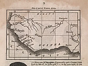
Map of Guinea
Medium
Classification
Department
Smithsonian Collection
Museum
Smithsonian American Art Museum
Credit
National Portrait Gallery, Smithsonian Institution
Accession Number
AD/NPG.2018.2.1
Rights
Public Domain
Tags
Art Historical Context
Step into the world of 19th-century cartography with *Map of Guinea*, a finely detailed print created by John Warner Barber in 1840. Barber (1798–1885), a prolific engraver and from Connecticut, was renowned for his to popular history books and atlases. Working primarily in wood and steel engraving, he captured landscapes, historical scenes, and maps with meticulous precision, making complex information accessible to everyday readers through affordable printed volumes—like the book from which this piece likely originates. This print reflects the era's burgeoning fascination with global geography amid American expansionism and exploration. Guinea, referring to the coastal region of West Africa, was a focal point in transatlantic trade, missionary accounts, and abolitionist literature. Barber's technique—likely steel engraving—allowed for intricate lines and shading that conveyed topography, rivers, and settlements with remarkable clarity, a hallmark of early industrial printing innovations. Housed in the Smithsonian American Art Museum's collection (with credit to the National Portrait Gallery), it exemplifies how prints democratized knowledge, bridging art and education for curious audiences. Today, this modest yet significant map invites us to ponder the interconnected histories of exploration and representation, reminding us how visual tools shaped perceptions of distant lands.