
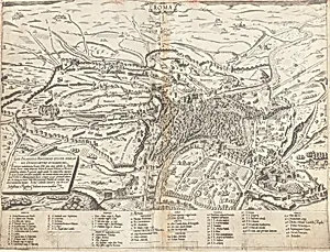
Topographical Map of Modern Rome
Medium
engraving
Dimensions
overall: 41.4 x 55 cm (16 5/16 x 21 5/8 in.)
Classification
Department
CG-E
Museum
National Gallery of Art, Washington, D.C.
Credit
Gift of Lois and Robert Erburu
Accession Number
2000.119.1.e
Rights
Public Domain
Art Historical Context
Step into the bustling streets of 16th-century Rome withTopographical Map of Modern Rome (1561), an engraving by Sebastiano di after designs by Giovanni Antonio Dosio Measuring 41.4 55 cm, this print captures the Eternal City as it thrived during the Renaissance, showcasing its churches, palaces, and urban layout with remarkable precision. Dosio, a skilled Italian architect and draughts active in Rome, was renowned his accurate *vedute*—topographical views that documented the city's transformation amid post-Sack reconstruction and papal grandeur. Engraving, the medium here, was revolutionary for its ability to reproduce intricate lines and fine details on a large scale, making complex maps accessible to scholars, pilgrims, and collectors across Europe. This technique allowed Di Re to faithfully translate Dosio's meticulous observations, highlighting Rome's "modern" evolution from ancient ruins to a vibrant Counter-Reformation hub. A gift to the National Gallery of Art from Lois and Robert Erburu, this print offers a window into how Renaissance cartography blended art and science, preserving a snapshot of Rome's golden age for posterity. Imagine tracing the Tiber or spotting landmarks like St. Peter's—it's history etched in copperplate elegance!